
I just came back from a great weekend camping with Brenda and Radar at #CroftStatePark in the SouthCarolina up-state. Brenda rode with friends and I took Radar on his first ever, real trail hike! We covered about 11 miles in one day with 8.5 of it along the Croft Passage of the Palmetto Trail. While he and I have gone for walks before, this was Radar’s first real hiking on a trail in the woods venture, and he did really really well, he’s such a good boy!
Tag: UltimateOutsider
This park has a heavy slant toward horses and dogs, but don’t be mislead. H. Cooper Black Jr. Memorial Field Trial and Recreation Area is an outstanding destination with unique facilities and terrain to explore.
I found H. Cooper’s openness a pleasant change from some of the smaller parks within the state. While there aren’t really “hiking” trails here, there are acres of wilderness to explore. I found the freedom of walking across the expansive rolling hills with their combination of open tall grass fields, pine forests, and waterfowl ponds nestled between, amazingly enjoyable and refreshing.
One of fun things I enjoyed about this park, was letting Radar off leash when we were out in the fields and at the ponds (dogs must be on lease near the camp sites). We even tried a little retriever training at the ponds (‘turns out the pup can’t swim – but that’s a story for another time). Most state parks have some pretty strict lease rules which makes it a little difficult to train with him for hiking, so it was nice to be able to roam in the fields and woods with him.
This park is one of newest and largest in the SC park system. Located in Chesterfield County, just about 5.6 miles South of Cheraw, H. Cooper Black was added to the park system in 1994. With it’s 7000 acres, it is the fourth largest in the South Carolina State Park system. The two big things in the park are the 20 miles of equestrian trails and the retriever training & events. But don’t let not having a horse keep you away. This park it is open, pleasant, and definitely worth the trip away from civilization. I look forward to returning to H. Cooper Black again.
Favorite Time of year: Anytime for camping.
Things to Know: If you like animals such as horses and dogs, you will like H. Cooper Black.
Camping: Camping is available at H Cooper Black. Please contact the park from 11 a.m. to noon, daily, at 843-378-1555 for camping reservations and information (Reservations Required).
Pet friendly: Pets must be voice command controlled or kept on a leash or in a kennel while in the camping area or within 1/4 mile of the camping area.
Getting There: H Cooper Black is in the Eastern midlands of South Carolina, just North of Florence and just South of Cheraw, right off highway 15. It’s about a 3 hour drive from the Charleston area.
#
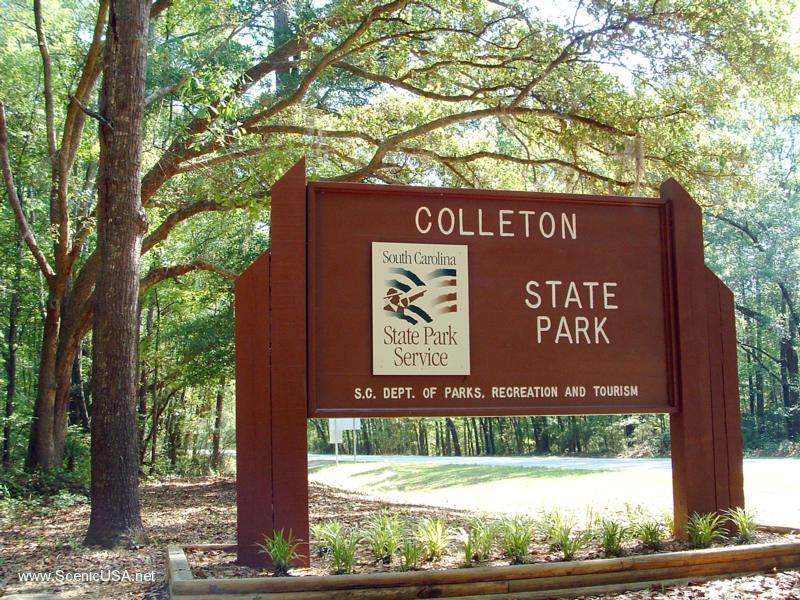
This one is a little different. With “just” a .3 mile interpretive trail, hiking is not really the main draw, but yet Colleton State Park is a hidden little gem in the South Carolina State Park system.
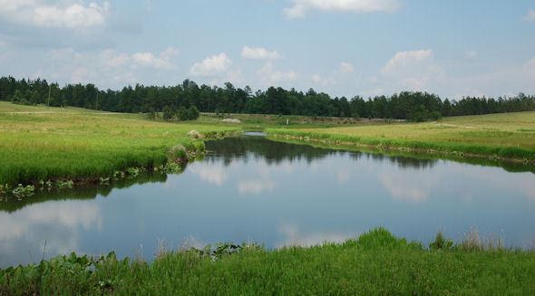
Nestled on the banks of the amazing Edisto River, this 34 acre park serves as the headquarters of the Edisto River Canoe and Kayak Trail. The Edisto River is the longest free-flowing black-water river in North America and offers some 63 miles of incredible canoeing & kayaking. Having a watercraft is not a requisite for visiting this park. While this park is the smallest in the SC park system, located in Colleton County, just off I-95, this 34 acre park is a popular dropping in point for paddlers, fishermen, and anyone seeking a break from the hustle and bustle of life.
I have camped at Colleton State Park dozens of times over the years (with and without a canoe) and am impressed with the parks steady improvements. Every year there seems to be more and more done to improve the park and services offered. While I’m usually found in the group or primitive campsite, there are about 25 standard camping sites, including a cabin overlooking the Edisto River. The short Cypress Swamp interpretive trail runs from the park entrance down through to the river side Canoe Dock.
Favorite Time of year: Summer for paddling, Anytime for camping.
Distance: About .3 miles.
Things to Know: This is an Easy hike.
Camping: Camping is available at Colleton State Park (reservations required).
Pet friendly: Must be leashed at all times, including the forest, okay everywhere outdoors except cabin and lodging areas of the park.
Getting There: Colleton State Park is just East of I-95, between Walterboro and St. George, right off highway 15. It’s about less than 1 hour drive from the Charleston. .area.
#
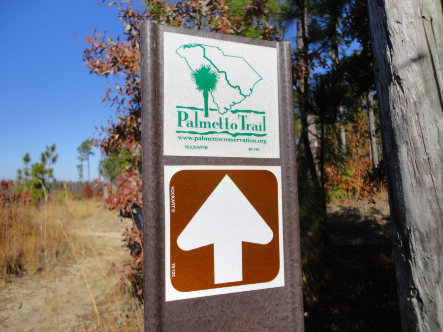
Looking for a great one day hike? Then this may be the answer. This passage of South Carolina’s Palmetto Trail snakes through the Manchester State Forest, linking Mill Creek County Park with Poinsett State Park. The High Hills of Santee Passage trail gets its name from the high, rolling sandy dunes, which are part of the regional geology. These rolling hills are the ancient ocean shoreline found in the state’s midland area. This is one of my favorite hikes when introducing new hikers to the trail.
Located in Sumter County, near the Northern side of Santee Lake, this 10 mile trail winds through the forest from Sumter County’s Mill Creek Park (+-195’), North up to Poinsett State Park. As the Manchester forest is state managed, you will pass through a couple areas which have been logged in the past and are now in various stages of regrowth. The term forest however is a little misleading. With fairly diverse terrain, including rolling sand ridges, mixed pines and hardwood forest, creeks, and even a patch of quicksand, there is plenty to keep the hike interesting every step of the way.
Of course you can hike in either direction, I prefer starting at Mill Creek Country Park and Hiking toward Poinsett State Park. The southern end of the trail is a bit more sandy and easier to travel through while you’re fresh. Towards the northern end of the trail you enter more rolling hills and wooded sections. As you come up from Shanks Creek crossing, there is a parking lot area before the trail crosses Poinsett Park Road. You are within the last few miles before entering the state park. With a latrine here, this is a great spot to take a short break before the last leg of this hike. Crossing over the road you pick up the trail again. You will step into another completely different type of wooded area as you enter a forest of scrub oaks draped with Spanish moss. This is one of my favorite sections of this hike. As the trail enters the park, it crosses and drops off to the left of the park road and winds down around the creek as you head toward and around the Old Levi Mill Pond. You will comes out of the woods and cross the earthen dam holding back Old Levi Mill Pond. While you are there, take a few minutes and explore the Singleton Grist Mill ruins and old grinding wheel. You end your hike at the park visitors center (+-100’) trail head at the parking lot.
Favorite Time of year: Fall through Spring
Distance: About 10 miles
Things to Know: This is a Moderately Easy hike.
Camping: Camping is available at both Mill Creek County Park and Poinsett State Park (reservations required). Both parks have restrooms, bathhouses, and parking. For all permit and reservation information at Mill Creek county park, call Steve at (803) 436-2248.
Pet friendly: Must be leashed at all times, including the forest, okay everywhere outdoors except cabin and lodging areas of the park.
Getting There: Poinsett State Park and Mill Creek Park are both located near on the Northern side of Santee Lake, and West of the town of Sumter, in Sumter County, South Carolina. It’s about a 1 hour drive from the Charleston area.
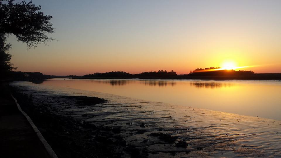
Need a quick getaway? Then hike this out and back. Just a short hop from Charleston, this trail winds down along the Intracoastal Waterway to the southern terminus of the Palmetto Trail and the Buck Hall Recreation Area.
This trail has a lot of hiking flexibility. If you are hiking solo or with only one vehicle or want to simply do the extra mileage, you can hike this trail out & back in a day, enjoying your trail lunch at the Buck Hall Recreation Area. With a couple vehicles, you can do a quick one way hike in either direction. I prefer hiking to the recreation area as there are picnic tables, bathrooms, and waterfront scenery which are nice amenities while you enjoy a lunch break.
For an out and back day hike, park at the Palmetto Trail Swamp Fox trail head on the west side of Hwy 17. Heading north on Hwy-17, you will go past the trailhead before you get to a turn-around on the divided highway. This trailhead is a little hard to pick out but it is just after Steed Creek and before Murell roads (you went too far if you get to the St. James AME Church). Once you get parked and geared up, the trail heads north out of the parking lot for about a half mile where it connects to the Swamp Fox portion of the Palmetto Trail. You’ll head East to branch off towards Awendaw. Heading to the West, the main trail will continue as the Swamp Fox portion of the Palmetto Trail. The Awendaw portion of the trail will loop back easterly along an old railway bed then following a dirt road, will head southerly crossing Hwy-17 (use caution) and continue to the canoe launch ramp on Awendaw Creek. This is a nice place for a short break. You can sit, enjoy a snack, and watch the water flow by. You’re about halfway to the recreation area here. From the canoe ramp, the trail will generally following the creek winding along the salt marsh and through the coastal palmettos, scrub oaks, and pines. You will cross over several foot bridges until the creek enters the Intracoastal Waterway. The trail loops back to the North just a short stretch and then turn southerly as it enters and ends at the Buck Hall Recreation Area boardwalk. The recreation area has a number of shaded picnic area where you can sit and enjoy lunch and views of the intracoastal waterfront.
Favorite Time of year: Fall through Spring.
Distance: 7.1 miles (one way)
Things to Know: This is an easy hike. If day hiking and leaving a vehicle at the Buck Hall Recreation Area there is small a day use/parking fee. Remember, this is the Lowcountry of South Carolina, so be prepared for a few wet parts along the trail, especially after a good rain. During the warmer months, the South Carolina mosquitoes can be a bit … ferocious.
Camping: Waterfront camping and restrooms are available at Buck Hall Recreation park (reservations required).
Pet friendly: Must be leashed at all times.
Getting There: Located along US-17 just a short distance from downtown, it’s about a 40 minute drive from the Charleston area.
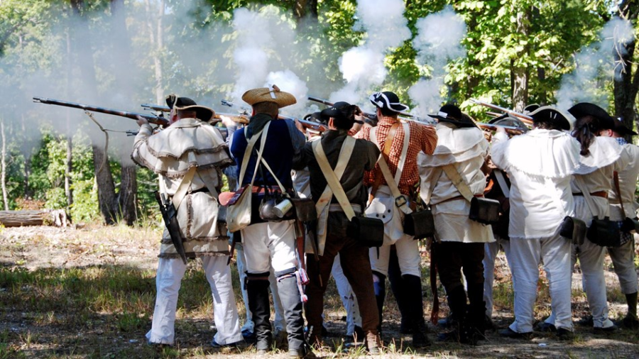
This is a great hike any time but more so during reenactment weekends. The national park hosts several living history events with period encampments and demonstrations throughout the year. I normally have done this hike over the Memorial Day weekend inconjunction with the park’s “Military Through the Ages” event. The historic significance of the battle ground really is driven home as you near the end of the hike. You get a real sense of what life and travel was like 200 years ago.
This 16 mile trail loops through both Kings Mountain State Park and Kings Mountain National Military Park. You can pick up the trail from one of the organized group primitive camping sites (+-800′) or from the state park camp ground, the trail loop conveniently passed both. Water and latrines are available in both areas. You will start out heading South and wind towards the South-west as the trail takes you over some rolling hills. The trail passes several wilderness designated camp sites and streams along the way. Near the state park’s southern boundary, the trail will make a fairly sharp turn to the North and rising up and away from the water. Just before this direction shift happens, the stream flattens out a little with some low banks. This is a good place to top off your water. The Garner Creek Campsite (+-700′) on the national park side is on high ground and dry. There is another stream past the Garner Creek Campsite but it’s about a quarter mile after the campsite. Once the trail shifts to the North, it rises out of the cooler valleys, becomes a little dryer and warmer. You know you are getting close to the camp site when you cross a dirt road. The Garner Creek Campsite is clearly marked and the only designated wildernes campsite of the national par side.
Up and on the trail the next morning this section goes pretty quickly with a run up bowns’s mountain and exploring the battle ground visitors center. about a mile after you leave Garner Creek, you will come to a spur trail for Browns Mountain (1045′). Summiting this peak is a short run up to the top of Brown’s Mountain and back down. The visitors center is only a couple short miles from here. The trail loop passes to the North of the battle ground and visitor center. Hike the spur trail on in for a stop at the national park visitor center.
This is a must do if you have not been here before. First of all, the visitor center has bathrooms and water. The area near the bathrooms is shaded and a great place to eat lunch. Second, but probably most importantly, the visitor center and 1.5 mile self-guiding walking trail around the battle field (+-1020′) is the heart of the park and key to understanding the history of the site. One of the cool things about Kings Mountain is the connection to the Appalachian Trail in the Roan Mountain area. In the late September-early October of 1780 (the rebel Americans were knee deep in a not-going-so-well break-away revolt against the British empire), hundreds of men crossed what is today the Appalachian Trail near the Over Mountain Shelter in Tennessee and hiked 80 miles in to history at the Battle of Kings Mountain, changing the tide of the Revolutionary war. Hiking these areas really adds a depth and an order of magnitude to history you just can’t get from a text book.
After touring all of the sights at the national park visitor center, simply retrace your way back to the loop trail and continue the remaining few miles to your starting point.
Favorite Time of year: Memorial Day Weekend, but check the park schedule for reenactments events.
Distance: 16 miles (the 1.5 mile battle field trail is a bonus)
Things to Know: This is a moderate hike. The actual battle ground is in the national park with regular park camping on the state park side. The 16 mile trail loops through both.
Camping: Primitive on the trail. Primitive, tent site, and cabins designated within the park (reservations required). There are several primitive trail camp sites on trail in the state park, however on the national park side camping is only allowed at Garner Creek Campsite.
Pet friendly: Mostly pet friendly, must be leashed at all times, okay everywhere outdoors except cabin and lodging areas of the park.
Getting There: Located near the Northern border of the state, Kings Mountain State Park is in Cherokee and York Counties, South Carolina, just to the West of Charlotte North Carolina. It’s about a 4 hour drive from the Charleston area.
#
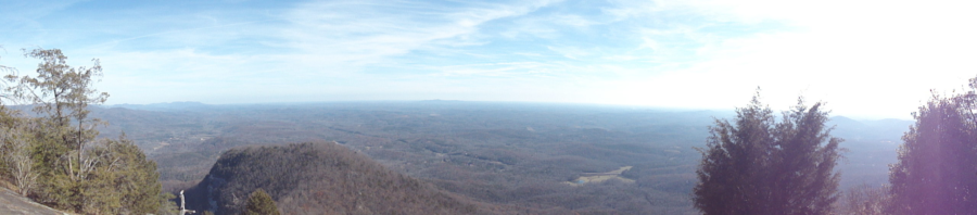
With some challenging hiking and amazing views, this Table Rock trip is one of my favorite backpacking campouts in the state. Any time of the year.
This trip strings together a combination of trails which basically form a 12.5 mile loop around, in and out of the park. As the park rules state you can’t camp within Table Rock State Park (other than in the designated campground areas), this hike takes you out to a campsite on the adjacent Foothills Trail running next to the West park boundary for the night. The next day you will come back in to the park and summit two of South Carolina’s higher peaks including Table Rock. Table Rock is a mountain with a bald face providing amazing views. Sitting on the face of of Table Rock you can eat your lunch and on a good day, see halfway to Columbia.
The Table Rock State Park area is in general, on a leading edge of the blue ridge mountains which skims the border between South and North Carolina. This state park includes the tallest mountain totally within the state, Pinnacle Mountain (3425′) and of course Table Rock Mountain (3124′). Just as a footnote, the highest point in South Carolina is the nearby Sassafras Mountain (3563′), but it straddles the border between South and North Carolina.
The Trail: You will start in the parking lot Near the Nature Center (1160′), located just past Pinnacle Lake. You can leave your vehicle in the parking lot overnight, but you must display a valid parking permit. You can pick up a parking permit at the park Visitors Center (located across Highway 11 next to the East park entrance). Once you’ve parked, gather your gear and head to the Nature Center trail head. Hikers must complete a trail registration form at the kiosk before hiking the trails. I also usually checked in with the Nature Center if they are open. They are a good source for trail information before you head out. Bathrooms and water sources at located at the Nature Center.
Leaving from the nature center, the trail is easy along the boardwalk and paved portions along Carrick Creek, but rapidly increase in difficulty as you shift to the Pinnacle Mountain Trail and continue up and West towards Pinnacle Mountain. There is a little spur trail which take you to the Mill Creek Falls. The falls are somewhat seasonal, so depending on the time of year and amount of rain fall there may or may not be any water for there to be falls. You’ll continue towards Pinnacle Mountain passing Bald Knob (2849′) which offers a great view and is a good place to take a break. The trail continues and then splits just before Pinnacle Mountain. This split away from the mountain will take you down and out of the park to campsites on the Foothills Trail. The first big campsite you come to is one of my favorites. It’s furthest from the water source but the site has an open view to the East which will catch the sunrise. If you continue along the foothills trail you will pass some more secluded camping sights on the way (+-200 yards) to a strong water source.
Once you are ready to hit the trail again in the morning, you’ll retrace the route back and up in to the park to the Pinnacle Mountain trail and continue up to summit Pinnacle Mountain. The wooded peak can be a little anticlimactic and depending on the time of year you may have a limited view of the surrounding areas. What ever the view you have here, it now gets better as you go. Just to the north of the summit you’ll pick up the Ridge Trail and continue on along the ridge line between the Pinnacle and Table Rock mountains. There is a bit of a saddle at Panther Gap where the Ridge Trail and Table Rock Trail intersect. Depending on your pace and progress, you can either lunch here or continue on and lunch on Table Rock. If you’re inclined, you can ditch your packs out of sight to the north of the trail and slack-pack up the rest of the way to Table Rock (you’ll comeback here later). Some of the remaining trail up to Governors Rock (2854′) and on to Table Rock can be a bit of a scramble. Depending on the time of year, I’ve encountered sheets of ice on Governors Rock which definitely increased the challenge factor. There is a summit sign at the peak of Table Rock but continue past and the trail slopes down and will lead to the South Eastern balds over looking the entire state of South Carolina. It’s probably worth noting here, the bald rock face is a huge curved rock. It slopes more as you head out on the bald more. There is no “edge” to tell you to “stop here.” It just curves down more. Be careful. When you are done enjoying the breathtaking views, simply retrace your route back to Panther Gap and take the Table Rock Trail down and back to the Nature Center where you started. Take your time descending as the Table Rock Trail is steep and can be hard on the knees.
Favorite Time of year: Any
Distance: 12.5 miles
Things to Know: This is a strenuous hike. The hiking trails within the park officially close ½-hour before dark and overnight camping is not permitted on park trails.
Camping: Primitive on the Foothill Trail. Primitive, tent site, and cabins designated within the park (reservations required).
Pet friendly: Mostly pet friendly, must be leashed at all times, okay everywhere outdoors except cabin and swim beach areas of the park.
Getting there: Located near the North-West border of the state, Table Rock State Park is in Pickens County, just to the NNW of Greenville South Carolina. It’s about a 4 hour drive from the Charleston area.
Table Rock SC Webcam
(as seen from the visitors center live webcam)
#