With some challenging hiking and amazing views, this Table Rock trip is one of my favorite backpacking campouts in the state. Any time of the year.
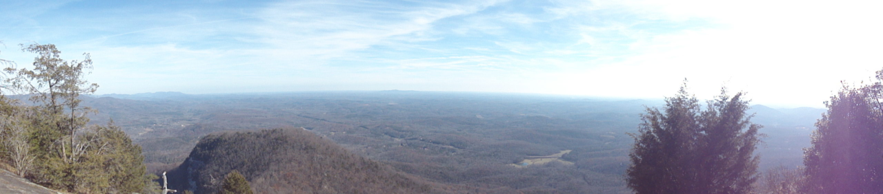
This trip strings together a combination of trails which basically form a 12.5 mile loop around, in and out of the park. As the park rules state you can’t camp within Table Rock State Park (other than in the designated campground areas), this hike takes you out to a campsite on the adjacent Foothills Trail running next to the West park boundary for the night. The next day you will come back in to the park and summit two of South Carolina’s higher peaks including Table Rock. Table Rock is a mountain with a bald face providing amazing views. Sitting on the face of of Table Rock you can eat your lunch and on a good day, see halfway to Columbia.
The Table Rock State Park area is in general, on a leading edge of the blue ridge mountains which skims the border between South and North Carolina. This state park includes the tallest mountain totally within the state, Pinnacle Mountain (3425′) and of course Table Rock Mountain (3124′). Just as a footnote, the highest point in South Carolina is the nearby Sassafras Mountain (3563′), but it straddles the border between South and North Carolina.
The Trail: You will start in the parking lot Near the Nature Center (1160′), located just past Pinnacle Lake. You can leave your vehicle in the parking lot overnight, but you must display a valid parking permit. You can pick up a parking permit at the park Visitors Center (located across Highway 11 next to the East park entrance). Once you’ve parked, gather your gear and head to the Nature Center trail head. Hikers must complete a trail registration form at the kiosk before hiking the trails. I also usually checked in with the Nature Center if they are open. They are a good source for trail information before you head out. Bathrooms and water sources at located at the Nature Center.
Leaving from the nature center, the trail is easy along the boardwalk and paved portions along Carrick Creek, but rapidly increase in difficulty as you shift to the Pinnacle Mountain Trail and continue up and West towards Pinnacle Mountain. There is a little spur trail which take you to the Mill Creek Falls. The falls are somewhat seasonal, so depending on the time of year and amount of rain fall there may or may not be any water for there to be falls. You’ll continue towards Pinnacle Mountain passing Bald Knob (2849′) which offers a great view and is a good place to take a break. The trail continues and then splits just before Pinnacle Mountain. This split away from the mountain will take you down and out of the park to campsites on the Foothills Trail. The first big campsite you come to is one of my favorites. It’s furthest from the water source but the site has an open view to the East which will catch the sunrise. If you continue along the foothills trail you will pass some more secluded camping sights on the way (+-200 yards) to a strong water source.
Once you are ready to hit the trail again in the morning, you’ll retrace the route back and up in to the park to the Pinnacle Mountain trail and continue up to summit Pinnacle Mountain. The wooded peak can be a little anticlimactic and depending on the time of year you may have a limited view of the surrounding areas. What ever the view you have here, it now gets better as you go. Just to the north of the summit you’ll pick up the Ridge Trail and continue on along the ridge line between the Pinnacle and Table Rock mountains. There is a bit of a saddle at Panther Gap where the Ridge Trail and Table Rock Trail intersect. Depending on your pace and progress, you can either lunch here or continue on and lunch on Table Rock. If you’re inclined, you can ditch your packs out of sight to the north of the trail and slack-pack up the rest of the way to Table Rock (you’ll comeback here later). Some of the remaining trail up to Governors Rock (2854′) and on to Table Rock can be a bit of a scramble. Depending on the time of year, I’ve encountered sheets of ice on Governors Rock which definitely increased the challenge factor. There is a summit sign at the peak of Table Rock but continue past and the trail slopes down and will lead to the South Eastern balds over looking the entire state of South Carolina. It’s probably worth noting here, the bald rock face is a huge curved rock. It slopes more as you head out on the bald more. There is no “edge” to tell you to “stop here.” It just curves down more. Be careful. When you are done enjoying the breathtaking views, simply retrace your route back to Panther Gap and take the Table Rock Trail down and back to the Nature Center where you started. Take your time descending as the Table Rock Trail is steep and can be hard on the knees.
Favorite Time of year: Any
Distance: 12.5 miles
Things to Know: This is a strenuous hike. The hiking trails within the park officially close ½-hour before dark and overnight camping is not permitted on park trails.
Camping: Primitive on the Foothill Trail. Primitive, tent site, and cabins designated within the park (reservations required).
Pet friendly: Mostly pet friendly, must be leashed at all times, okay everywhere outdoors except cabin and swim beach areas of the park.
Getting there: Located near the North-West border of the state, Table Rock State Park is in Pickens County, just to the NNW of Greenville South Carolina. It’s about a 4 hour drive from the Charleston area.
Table Rock SC Webcam
(as seen from the visitors center live webcam)
#
1 Pingback